What lies beneath: The looming crisis in our groundwater systems
95 percent of the Earth’s freshwater is stored in groundwater systems. Yet despite a number of Australian cities depending on this vital resource, what lies just metres below our feet remains largely an unknown land.
It was shocking. A huge maw of open ground appeared, the size of an intersection, exposing the broken entrails of civil infrastructure in downtown Fukuoka. It is not often that we think of the subsurface, yet this open sore of pipes, cables, and grubby water revealed for a brief moment the hidden city beneath the tarmac. Round-the-clock teams toiled to repair the road in record time, in what seemed more a matter of municipal dignity than traffic necessity. Like the shock of seeing human organs visible and unprotected, this urban trauma was urgently patched up and the city got back to work.
Across the world such ground trauma is routine. Every season is sinkhole season in Florida and residents are used to peering into the subterranean world. The city is collapsing in on itself as the warm acidic rainwater that keeps the city green filters down into the karst limestone below and eats away at it, creating cavities in the rock. These cavities routinely collapse, dragging whatever’s above down into the depths. It amounts to a normalised catastrophic condition resulting in up to 6500 insurance claims every single year.
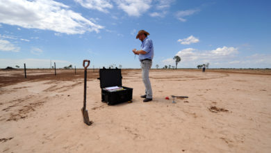
Yet acidic rain is only one factor contributing to this landscape of sinkholes. Another factor causes Florida insurance surveyors to pull around little trailers with ground penetrating radar equipment, so they can determine whether they’re looking at a sinkhole or just a garden-variety subsidence.
The state’s fertile soil and warm, moist air has given rise to a vast landscape of strawberry fields and citrus groves, all irrigated with groundwater from a shallow aquifer. This irrigation doesn’t just occur in the summer months but continues into the winter months, when farmers protect tender, new strawberry leaves during cold snaps with warm water from the aquifer. After a particularly bitter cold snap in 2010, aggressive pumping by the strawberry growers reduced the water table level by 18 metres in less than two weeks. To put this into an Australian context, when Perth experiences a dry year, the Gnangara groundwater system (one of the city’s sources of fresh water) water table can drop by one metre, causing extensive Banksia woodland die off.
Sinkholes such as this are common in Florida. Image courtesy of Rob Melendez
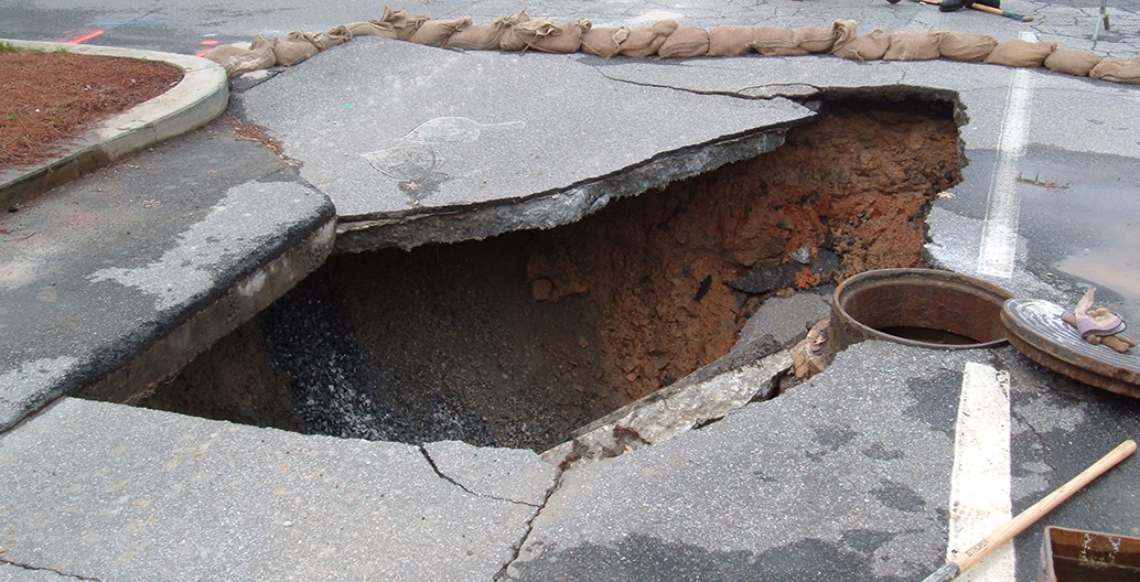
Sinkholes such as this are common in Florida. Image courtesy of Scott Ehardt
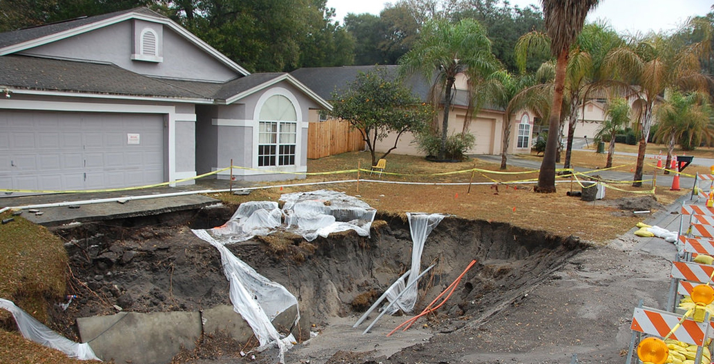
Sinkholes such as this are common in Florida. Image courtesy of US Geological Survey
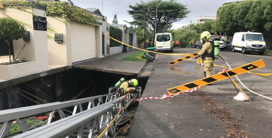
Point Piper pot holes. Image courtesy of NSW Fire and Rescue
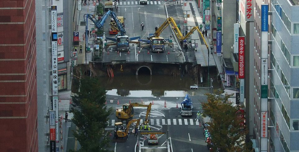
Traffic-stopper in Fukuoka. Image courtesy of Muyo
Aside from destruction of flora, when water is removed from sediment, the subsurface loses part of its structure and with that, its capacity to hold the weight of the land above it. That January in Florida, as a billion gallons of groundwater was pumped in just 11 days, towns in the region suffered over 80 large-scale sinkholes. It shut down an elementary school, closed roads and highways, and threatened the structural integrity of a 500,000-gallon water tower. Governments threw more money at the problem than at the damage caused by the unusually severe hurricane season.
Years later, neither cause nor effect has been adequately addressed as local officials nervously watch as migrants, lured by the sunny promise of Florida, push suburban development into rural land that is at an increasing risk of collapse.
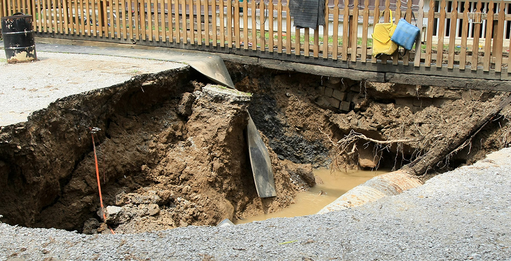
Fukuoka and Florida are just two examples of what can happen when changes underground dramatically impact what happens above ground. In Australia, the exclusive Sydney suburb of Point Piper recently witnessed the formation of a dramatic sinkhole the size of a swimming-hole, just one kilometre from Prime Minister Malcolm Turnbull’s home. Stormwater had washed away sediment from right under the footpath.
Although stories such as these highlight the extent to which subsurface waters can be destructive, much more often they are life-giving. In fact, around two billion people depend on them, which is why the groundwater problems facing South Asia go well beyond subsidence and sink holes.
Bore-water boom and bust
Pakistan, India, Nepal, Bangladesh and China currently account for nearly half of the world’s total groundwater use. This is particularly worrying for the urban poor of those countries. Degraded and contaminated groundwater is forcing families to rely on water vendors, blackmarket water sellers or water ATM’s to buy safe water at a premium price. The sheer scale of the number of people vulnerable to water stress in South Asia is put into context by Bharat Dahiya from the Social Research Institute of Chulalongkorn University in Bangkok, who said that “by 2012 the urban slum population [of South Asia] was already a staggering 200 million — almost one-third of the 579 million total urban population.”
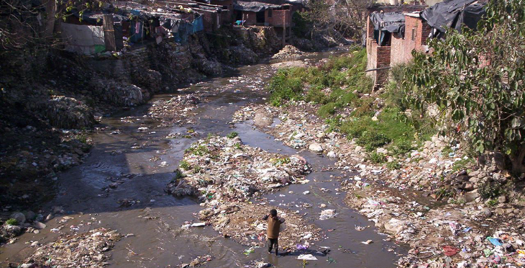
Rubbish laden rivers conspires with depleted groundwater to form a health disaster. Image courtesy Meg and Rahul
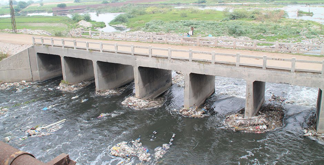
Rubbish laden rivers conspires with depleted groundwater to form a health disaster. Image courtesy WWF
Few places are more water-stressed than Pakistan, whose water profile has changed rapidly from being a water abundant country, to one of looming environmental catastrophe. Its groundwater problem is so severe that it is considered a greater threat to national security than terrorism. To a large extent, this is due to an agricultural sector that consumes 90 percent of the country’s water resources through a huge continuous irrigation system that covers an area three times the size of Switzerland.
It was not always such. At one time Pakistan’s needs were comfortably met by water supplied from man-made canals and the 3000-kilometre-long Indus River and its tributaries. However, as its population grew, per capita water availability correspondingly declined from 5260 cubic metres per inhabitant in 1951 to 960 cubic metres per inhabitant in 2010 (by comparison, Australia’s per capita water availability is approximately 5500 cubic meters per inhabitant). To address water shortages, thousands of tube wells were injected into the Indus Basin aquifer, pumping vast quantities of groundwater, without regulation or limit to its use. With its water problems “solved”, Pakistan shot up the ranks to become the world’s fourth largest water user.
At first, easy water was a boon to farmers, as they sucked out water to irrigate their thirsty cash crops of wheat, rice, cotton and sugarcane. The dry desert, river plains of the Punjab are now lined with vast fields of snowy cotton blossoms. From the seventies to the nineties, farmers filled their pockets while the booming textile cities of Lahore and Karachi enthusiastically bought their crops to spin into the latest street-ware. But it could never last.
Falling groundwater levels, droughts, sap sucking whitefly plagues and poor plant growth led to sick or dying crops. As the costs of agriculture rose and the profits fell, particularly during climatic events, rural people began to move en masse to neighbouring provincial cities such as Lahore. Pakistan is now urbanising faster than anywhere else in South Asia. The UN Population Division estimates that Lahore’s current population of approximately seven million will exceed 10 million people by 2025.
Lahore’s deadly water
All of this has put a huge strain on the city of Lahore, on the edge of the Ravi River: one of the Indus River’s tributaries. A 2014 WWF-Pakistan report highlights the impact that falling water table levels, groundwater degradation and poor water stewardship is having on the city. According to the report 10,000 tube wells used for agriculture are rapidly diminishing the city’s water supply.
Falak Sher Khan from Pakistan Today writes, “Lahore alone has 2700 registered industries. Out of which 75 percent are consumers of ground water. As a result of this excessive ground water use in central Lahore, the ground water has dropped by a 40 metres and is predicted to drop by 70 metres by 2025.” That’s almost the height of a 20-storey building.
One consequence of this is that shallow groundwater that is rich in pollutants is now being pulled down towards the deep freshwater aquifer used for drinking. Such unsafe drinking water is an urgent threat to health in Pakistan. Hospitals record that 40 percent of all deaths annually are now due to water-borne diseases such as diarrhoea, typhoid, intestinal worms and hepatitis. Water-borne diseases now cause 250,000 child deaths every year in the country.
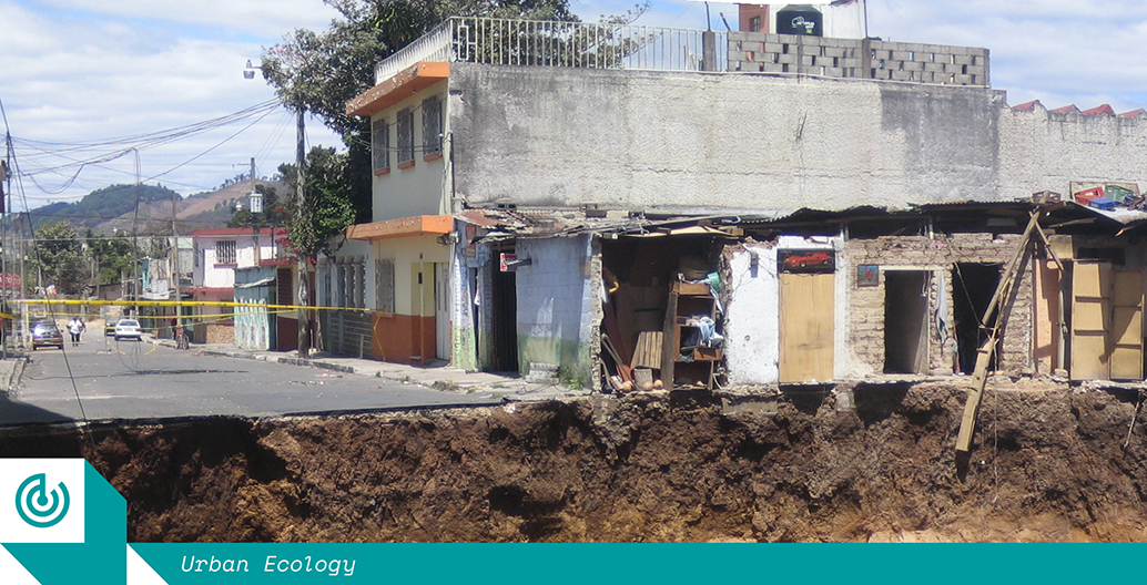
Taken together, a deadly cycle can be identified. Unregulated groundwater pumping for agriculture gives rise to an unsustainable population increase. When the water fails, large rural populations are forced to migrate to nearby cities. The city’s groundwater is then both dramatically depleted and at the same time contaminated by poorly controlled and unregulated urban pollution. Here in Lahore, as in many other countries around the world such as Mexico City, an urban catastrophe affecting tens of millions of citizens is slowly getting much, much worse.
The rise of urban geology
Against the backdrop of such catastrophic failures to manage and control water usage, the emerging disciplines of urban geology and geological communication have the capacity to make a big difference. In broad terms, urban geology tackles problems where the geosphere (geology), hydrosphere (water) and biosphere (biology) meet within urban environments. These new fields are revealing important discoveries about how we view what lies below.
According to Dr Hazel Gibson from Plymouth University, whose doctorate was in geocognition and communication, the public have important preconceptions and misconceptions regarding the urban subsurface, hydrological systems and hazards. In her research she has undertaken a number of experiments to compare how expert and non-expert participants perceive what lies underground and the results were instructive.
Participants were asked to draw their imagined view of what lay below a topographical surface. They were given a large white block topped with a contoured 3D surface covered by an aerial photo. Interestingly, in most cases the non-experts were extremely limited in their capacity to link surface conditions with the geology below it. Often, they simply left an empty band of white between entirely imagined underground features, and the landscape above it. Very few consciously linked visible topographical features, such as a mountain or river, to the invisible subsurface.
Gibson also asked non-experts to describe how water moves through the subsurface. Over half of respondents answered incorrectly, imagining the movement of water through the ground as underground rivers, which is in fact rarely the case.
Finally, non-expert participants had a strong anthropocentric perspective, understanding hazards such as flooding to be “human-made”. These views have important implications for those working to help cities with big, complex water problems like Perth or Lahore: cities whose water problems are caused by both natural and non-natural factors.
So how can urban designers, landscape architects and other built environment professionals work collaboratively with urban geologists to improve how we utilise or protect the subsurface environment in our booming cities? This is of particular interest when the urban subsurface, as we have seen in Florida, may be connected to changes in the earth system well beyond the city limits.
One inspiring European project tackling the issue is Sub-Urban. It is a network of cities, national geological surveys and research partners from 31 countries working together to improve the planning, development and management of the ground below cities. One of the people spearheading this new approach is Ignace van Campenhout from the City Development Corporation of Rotterdam. He has observed that urban developers and design professionals often overlook the subsurface during the initial phases of development. Ignoring the subsurface can cause delays, cost blowouts or lead to the poor exploitation of energy, water or space. Van Campenhout sees it as his responsibility to “seduce urban developers to incorporate the subsurface in their plans’’. Put simply, “careful deployment of the subsurface can enhance the value of the environment above ground”.
In acknowledging this need, the Sub-Urban group has created an online resource to share examples and stories of good practice in a number of European cities. Together they reveal how to effectively and efficiently utilise knowledge about the urban subsurface in the urban planning process.
Hamburg is a good example, having established an exemplary groundwater monitoring and management system over 10 years. The British Geological Survey is now using their example as an analogue for Glasgow’s groundwater challenges, putting into practice a collaborative process using shared geological and groundwater models.
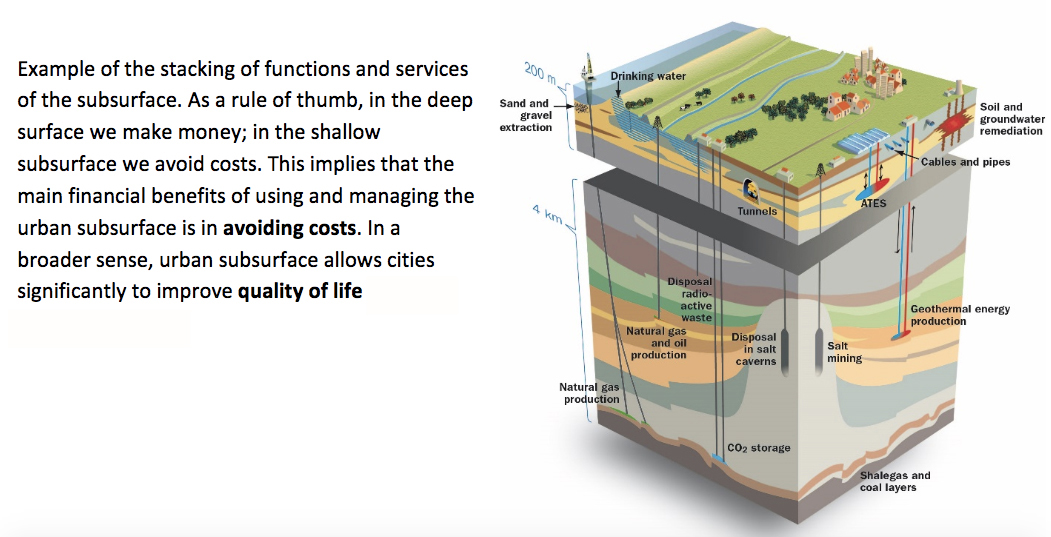
Suburban geological cross section. Image courtesy of Sub-Urban
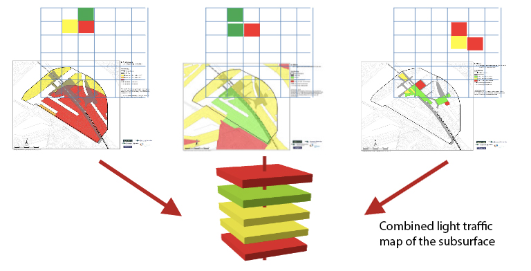
Applying 'traffic light' coding to subsurface uses. Image courtesy of Sub-Urban
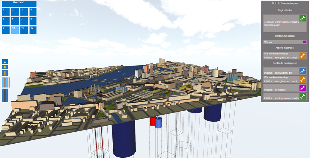
3D model linking the city to its subsurface. Image courtesy of City Development Rotterdam
It is a key ambition of the Sub-Urban group to help global policy-makers and decision-makers to make better informed decisions, particularly during the early stages of city planning. A good snapshot of this work is available in their report Out of Sight Out of Mind?. The report summarises current attitudes towards urban subsurface as only of interest where either great opportunities or great risks are presented, such as resource mining or earthquakes. Generally, beneficial subsurface conditions are taken for granted, and “the subsurface is only considered when adverse conditions manifest themselves, in which case they often referred to as unforeseen”. In other words, subsurface usually means nothing or trouble.
Developing an understanding of the subsurface takes time, but it is worth it. Van Campenhout observes that by collecting a vast amount of disparate subsurface data (soil, groundwater, energy, hazards, heritage, civil infrastructure etc) and turning it into useable information, you can begin to tap the city’s subterranean potential. In the past, if you wanted to know about a site in the city you would commission a survey. It would be site, problem and point-in-time specific. This process doesn’t respond well to the dynamic need of urban areas in Florida, the Punjab or Western Australia, where change is happening faster than a survey can be commissioned.
To tackle this, the City of Rotterdam now holds workshops with city planning and subsurface specialists, where underground maps are printed and pinned to a wall and small groups set about making a clear, readable “traffic light” map (which keys information densities from red to orange to green) on a particular subsurface theme. Once completed, a number of traffic light maps are merged into a single map of the subsurface, providing clear data on how the subsurface impacts urban planning and design.
Taking this type of approach even further, Helsinki is now the first city to have introduced an underground masterplan. In the process they have begun releasing valuable surface space by relocating some municipal facilities underground.
Meanwhile, the cities cooperating with Sub-Urban have proposed to develop a 3D Geo City Information Modelling (GeoCIM) concept, which expands on Building Information Modelling (BIM) and City Information Modelling (CIM), to make the modelling of both above and below surface data, at scales appropriate to a city, an explicit requirement of sustainable urban planning and management.
As a world first, The Sub-Urban project is creating a community of knowledge and practice, bringing together local municipalities, universities and institutes. This in turn allows distinct disciplines, from planning professionals and urban designers to landscape architects and geologists, to talk to each other.
When we look at Fukuoka, Florida or Lahore we see what happens, at both the local and regional scale, when we neglect the subsurface. By contrast, cities like Rotterdam and Hamburg inspire a new approach where different disciplines come together to build integrated data-sets into one complex, dynamic and information rich underground model. This in turn will be an indispensable tool for the regulation and planning of our urban subsurface.
Sinkholes and contaminated groundwater make it clear that the subsurface increasingly has the capacity to support, or literally undermine, the sustainable future of our cities. And that is something we cannot hide from.